


YMLT - Launceston
Located in Launceston, Australia
ICAO - YMLT, IATA - LST
Data provided by AirmateGeneral information
Coordinates: S41°32'43" E147°12'51"
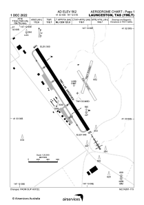
Elevation is 562 feet MSL.
View others Airports in Tasmania
Operational data
Special qualification required
Current time UTC:
Current local time:
Weather
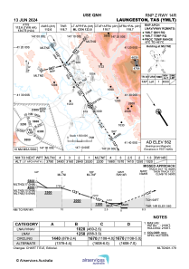
METAR: YMLT 291500Z AUTO 00000KT 9999 // NCD 02/M01 Q1025 RF00.0/000.2
TAF: TAF AMD YMLT 291115Z 2912/3012 02004KT CAVOK FM292100 VRB04KT 9999 SCT045 BECMG 3001/3002 17013KT 9999 SCT045 FM300900 13005KT 9999 SCT045
Communications frequencies: [VIEW]
Runways:
| RWY identifier | QFU | Length (ft) | Width (ft) | Surface | LDA (ft) |
| 14R | 147° | 6499 | 148 | ASP | |
| 32L | 327° | 6499 | 148 | ASP |
Airport contact information
Address: Launceston Australia
