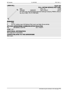


YLAH - Lawn Hill
Located in Mount Isa, Australia
ICAO - YLAH, IATA - LWH
Data provided by AirmateGeneral information
Coordinates: S18°34'33" E138°35'5"
Elevation is 404 feet MSL.
Magnetic variation is 5° East View others Airports in Queensland
Operational data
Special qualification required
Current time UTC:
Current local time:
Weather at : - ( 0 km )
METAR: PAOU 280438Z AUTO 32012KT 3SM BR OVC003 02/01 A2984 RMK AO2 FZRANO PNO $
Communications frequencies: [VIEW]
Runways:
| RWY identifier | QFU | Length (ft) | Width (ft) | Surface | LDA (ft) |
| 04 | 0° | 4002 | 0 | X | |
| 22 | 0° | 4002 | 0 | X |
Airport contact information
Address: Mount Isa Australia