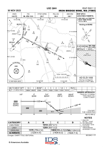
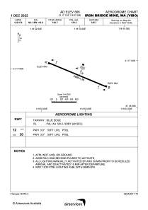


YIBO - Iron Bridge Mine
Located in Japal Camp, Australia
ICAO - , IATA - IBM
Data provided by AirmateGeneral information
Coordinates: S21°17'12" E118°52'59"
Elevation is 665 feet MSL.
View others Airports in Western Australia
Operational data
Special qualification required
Current time UTC:
Current local time:
Weather at : - ( 0 km )
METAR: TJBQ 272050Z 07016KT 10SM SCT018 SCT025 BKN090 28/22 A2992
Communications frequencies: [VIEW]
Runways:
| RWY identifier | QFU | Length (ft) | Width (ft) | Surface | LDA (ft) |
| 12 | 116° | 8202 | 98 | UNK | |
| 30 | 296° | 8202 | 98 | UNK |
Airport contact information
Address: Japal Camp Australia