


YGEL - Geraldton
Located in Geraldton, Australia
ICAO - YGEL, IATA - GET
Data provided by AirmateGeneral information
Coordinates: S28°47'46" E114°42'27"
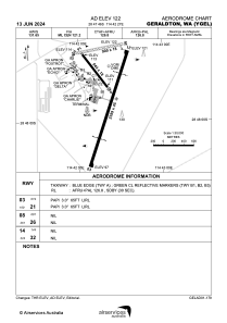
Elevation is 121 feet MSL.
View others Airports in Western Australia
Operational data
Special qualification required
Current time UTC:
Current local time:
Weather
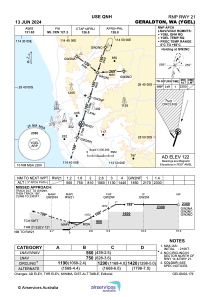
METAR: YGEL 041530Z AUTO 14008KT 9999 // NCD 15/11 Q1020 RF00.0/000.0
TAF: TAF YGEL 041103Z 0411/0506 17014KT CAVOK BECMG 0412/0413 14008KT CAVOK
Communications frequencies: [VIEW]
Runways:
| RWY identifier | QFU | Length (ft) | Width (ft) | Surface | LDA (ft) |
| 03 | 18° | 7838 | 148 | ASP | |
| 21 | 198° | 7838 | 148 | ASP | |
| 14 | 143° | 2769 | 59 | GVL | |
| 32 | 323° | 2769 | 59 | GVL | |
| 08 | 80° | 2953 | 59 | GVL | |
| 26 | 260° | 2953 | 59 | GVL |
Airport contact information
Address: Geraldton Australia

