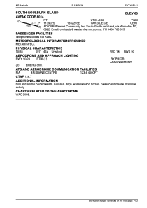


YGBI - South Goulburn Island
Located in South Goulburn Island, Australia
ICAO - YGBI, IATA - GBL
Data provided by AirmateGeneral information
Coordinates: S11°39'2" E133°22'55"
Elevation is 63 feet MSL.
View others Airports in Northern Territory
Operational data
Special qualification required
Current time UTC:
Current local time:
Weather at : - ( 0 km )
METAR: PKWA 282140Z AUTO 13016G20KT 5SM BR SCT013 BKN022 OVC045 27/25 A2987 RMK AO2 T02700252 TSNO
Communications frequencies: [VIEW]
Runways:
| RWY identifier | QFU | Length (ft) | Width (ft) | Surface | LDA (ft) |
| 10 | 100° | 4593 | 59 | X | |
| 28 | 280° | 4593 | 59 | X |
Airport contact information
Address: South Goulburn Island Australia