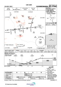
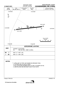


YCWA - Coondewanna
Located in Coondewanna Mining Camp, Australia
ICAO - YCWA, IATA - CJF
Data provided by AirmateGeneral information
Coordinates: S22°57'60" E118°48'48"
Elevation is 2327 feet MSL.
View others Airports in Western Australia
Operational data
Special qualification required
Current time UTC:
Current local time:
Weather at : - ( 0 km )
METAR: PATQ 041335Z AUTO 05020KT 3/4SM -SN BR FEW006 OVC016 M14/M16 A3009 RMK AO2 P0000 FZRANO TSNO
Communications frequencies: [VIEW]
Runways:
| RWY identifier | QFU | Length (ft) | Width (ft) | Surface | LDA (ft) |
| 08 | 83° | 6824 | 98 | UNK | |
| 26 | 263° | 6824 | 98 | UNK |
Airport contact information
Address: Coondewanna Mining Camp Australia