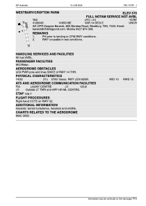


YCRF - Westbury / Crofton Farm
Located in , Australia
ICAO - , IATA -
Data provided by AirmateGeneral information
Coordinates: S41°28'4" E146°50'18"
Elevation is 570 feet MSL.
View others Airports in Tasmania
Operational data
Special qualification required
Current time UTC:
Current local time:
Weather at : YMLT - Launceston ( 32 km )
METAR: YMLT 291530Z AUTO 00000KT 9999 // NCD 02/M01 Q1025 RF00.0/000.2
TAF: TAF AMD YMLT 291115Z 2912/3012 02004KT CAVOK FM292100 VRB04KT 9999 SCT045 BECMG 3001/3002 17013KT 9999 SCT045 FM300900 13005KT 9999 SCT045
Communications frequencies: [VIEW]
Runways:
| RWY identifier | QFU | Length (ft) | Width (ft) | Surface | LDA (ft) |
| 14 | 0° | 2051 | 33 | UNK | |
| 32 | 0° | 2051 | 33 | UNK |
Airport contact information
Address: Australia