


YBIR - Birchip
Located in Birchip, Australia
ICAO - YBIR, IATA -
Data provided by AirmateGeneral information
Coordinates: S35°59'59" E142°55'3"
Elevation is 340 feet MSL.
View others Airports in Victoria
Operational data
Special qualification required
Current time UTC:
Current local time:
Communications frequencies: [VIEW]
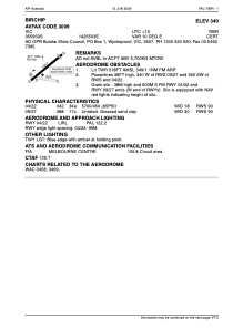
Runways:
| RWY identifier | QFU | Length (ft) | Width (ft) | Surface | LDA (ft) |
| 04 | 52° | 3422 | 59 | ASP | |
| 22 | 232° | 3422 | 59 | ASP | |
| 09 | 98° | 1719 | 98 | GRS | |
| 27 | 278° | 1719 | 98 | GRS |
Airport contact information
Address: Birchip Australia