


Y65 - Campbell-Pratt
Located in Indian River, United States
ICAO - Y65, IATA -
Data provided by AirmateGeneral information
Coordinates: N45°24'22" W84°35'54"
Elevation is 614 feet MSL.
Magnetic variation is -06° East View others Airports in Michigan
Operational data
Special qualification required
Current time UTC:
Current local time:
Weather at : KPLN - Pellston Rgnl/Emmet County ( 24 km )
METAR: KPLN 042354Z AUTO 05003KT 10SM CLR 17/09 A2983 RMK AO2 SLP105 T01670094 10239 20161 56031
Communications frequencies: [VIEW]
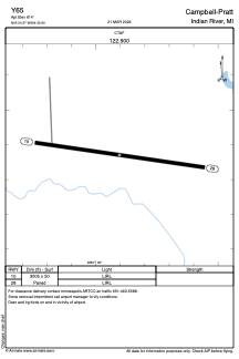
Runways:
| RWY identifier | QFU | Length (ft) | Width (ft) | Surface | LDA (ft) |
| 10 | 98° | 3005 | 50 | ASPH | |
| 28 | 278° | 3005 | 50 | ASPH |
Airport contact information
Address: Indian River United States