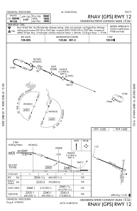
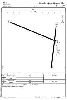


Y55 - Crandon/Steve Conway Muni
Located in Crandon, United States
ICAO - Y55, IATA -
Data provided by AirmateGeneral information
Coordinates: N45°31'22" W88°55'42"
Elevation is 1650 feet MSL.
Magnetic variation is -03° East View others Airports in Wisconsin
Operational data
Special qualification required
Current time UTC:
Current local time:
Weather at : KAIG - Langlade County ( 43 km )
METAR: KAIG 282355Z AUTO 07014G25KT 1 1/4SM +RA OVC011 04/04 A2991 RMK AO2 P0017 60049 T00390035 10056 20038
Communications frequencies: [VIEW]
Runways:
| RWY identifier | QFU | Length (ft) | Width (ft) | Surface | LDA (ft) |
| 01 | 0° | 2742 | 100 | GRASS | |
| 19 | 0° | 2742 | 100 | GRASS | |
| 12 | 0° | 3550 | 75 | ASPH | |
| 30 | 0° | 3550 | 75 | ASPH |
Airport contact information
Address: Crandon United States