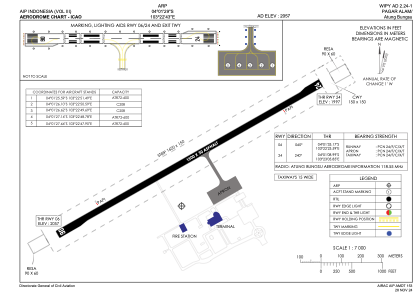


WIPY - Atung Bungsu
Located in Pagar Alam, Indonesia
ICAO - WIPY, IATA -
Data provided by AirmateGeneral information
Coordinates: S4°1'22" E103°22'43"
Elevation is 2093 feet MSL.
Magnetic variation is 0° East View others Airports in Sumatra Selatan
Operational data
Special qualification required
Current time UTC:
Current local time:
Weather at : - ( 0 km )
METAR: KLCI 201131Z AUTO 29004KT 10SM -RA FEW008 BKN015 OVC095 08/08 A2992 RMK AO2 RAE10B30 PRESRR P0000
Communications frequencies: [VIEW]
Runways:
| RWY identifier | QFU | Length (ft) | Width (ft) | Surface | LDA (ft) |
| 06 | 60° | 4396 | 98 | UNK | |
| 24 | 240° | 4396 | 98 | UNK |
Airport contact information
Address: Pagar Alam Indonesia