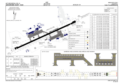


WIHH - Jakarta/Halim Perdanakusuma
Located in Jakarta, Indonesia
ICAO - WIHH, IATA - HLP
Data provided by AirmateGeneral information
Coordinates: S6°16'3" E106°53'11"
Elevation is 91 feet MSL.
View others Airports in Jakarta Raya
Operational data
Special qualification required
Current time UTC:
Current local time:
Weather
METAR: WIHH 200500Z 06009KT 5000 HZ SCT020 32/24 Q1007 RMK RA TO N METAR
TAF: TAF WIHH 200500Z 2006/2106 06008KT 5000 HZ SCT020 TEMPO 2006/2010 15014KT 3000 -TSRA FEW016CB BKN017 BECMG 2013/2015 36004KT 6000 BECMG 2019/2021 00000KT 4000 BR FEW020
Communications frequencies: [VIEW]
Runways:
| RWY identifier | QFU | Length (ft) | Width (ft) | Surface | LDA (ft) |
| 06 | 65° | 9843 | 148 | ASP | |
| 24 | 245° | 9843 | 148 | ASP |
Airport contact information
Address: Jakarta Indonesia