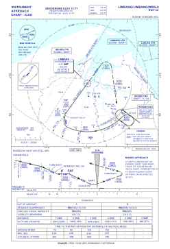
WBGJ - Limbang
Situé à Limbang, Malaysia
ICAO - WBGJ, IATA - LMN
Données fournies par AirmateInformation générale
Coordonnées: N4°48'30" E115°0'34"
Élévation : 15 feet MSL.
Voir autres Aéroports à Sarawak
Données opérationnelles
Special qualification required
Heure actuelle UTC:
Heure actuelle locale:
Météo à : WBSB - Brunei / International ( 18 km )
METAR: WBSB 160800Z 31006KT 9999 TS FEW016 FEW017CB BKN300 33/29 Q1006 NOSIG
TAF: TAF WBSB 160500Z 1606/1712 33008KT 9999 FEW015 FEW016CB BECMG 1612/1614 03004KT FEW014 FEW015CB TEMPO 1612/1616 4000 TSRA SCT014 FEW015CB
Fréquences de communication: [VIEW]
Pistes:
| Identifiant RWY | QFU | Longueur (ft) | Largeur (ft) | Surface | LDA (ft) |
| 04 | 37° | 4921 | 98 | ASP | |
| 22 | 217° | 4921 | 98 | ASP |
Coordonnées de l'aéroport
Adresse: Limbang Malaysia


