


WAWN - Bone / Arung Palakka
Located in Watampone, Indonesia
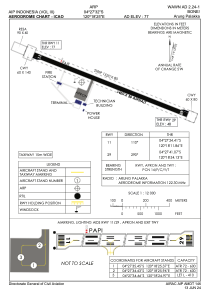
ICAO - , IATA -
Data provided by AirmateGeneral information
Coordinates: S4°27'32" E120°18'25"
Elevation is 131 feet MSL.
View others Airports in Sulawesi Selatan
Operational data
Special qualification required
Current time UTC:
Current local time:
Weather at : - ( 0 km )
METAR: KXSA 280035Z AUTO 00000KT 10SM CLR 14/11 A3033 RMK AO2 T01410113
Communications frequencies: [VIEW]
Runways:
| RWY identifier | QFU | Length (ft) | Width (ft) | Surface | LDA (ft) |
| 11 | 111° | 3740 | 98 | UNK | |
| 29 | 291° | 3740 | 98 | UNK |
Airport contact information
Address: Watampone Indonesia