


WAUM - Merdei/Jahabra
Located in , Indonesia
ICAO - , IATA - RDE
Data provided by AirmateGeneral information
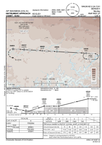
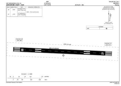
Coordinates: S1°35'29" E133°17'45"
Elevation is 385 feet MSL.
Magnetic variation is 2° East View others Airports in Irian Jaya
Operational data
Special qualification required
Current time UTC:
Current local time:
Weather at : - ( 0 km )
METAR: KQFX 260110Z AUTO 29001KT 8000 HZ CLR 18/11 A2985 RMK A02 TSNO
Communications frequencies: [VIEW]
Runways:
| RWY identifier | QFU | Length (ft) | Width (ft) | Surface | LDA (ft) |
| 09 | 93° | 1969 | 75 | UNK | |
| 27 | 273° | 1969 | 75 | UNK |
Airport contact information
Address: Indonesia