


WATS - Sabu/Tardamu
Located in Sabu, Indonesia
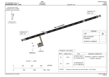
ICAO - , IATA - SAU
Data provided by AirmateGeneral information
Coordinates: S10°29'38" E121°50'46"
Elevation is 69 feet MSL.
Magnetic variation is 1° East View others Airports in Nusa Tenggara Timur
Operational data
Special qualification required
Current time UTC:
Current local time:
Weather at : - ( 0 km )
METAR: KXSA 200415Z AUTO 17003KT 10SM OVC008 12/12 A3004 RMK AO2 T01150115
Communications frequencies: [VIEW]
Runways:
| RWY identifier | QFU | Length (ft) | Width (ft) | Surface | LDA (ft) |
| 07 | 73° | 2953 | 75 | UNK | |
| 25 | 253° | 2953 | 75 | UNK |
Airport contact information
Address: Sabu Indonesia