


WATQ - Kisar Island / John Becker
Located in Kisar, Indonesia
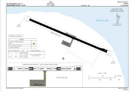
ICAO - , IATA -
Data provided by AirmateGeneral information
Coordinates: S8°1'5" E127°11'59"
Elevation is 90 feet MSL.
View others Airports in Nusa Tenggara Timur
Operational data
Special qualification required
Current time UTC:
Current local time:
Weather at : - ( 0 km )
METAR: LMML 161045Z 04006KT 350V080 9999 FEW080CB 19/14 Q1009 NOSIG
Communications frequencies: [VIEW]
Runways:
| RWY identifier | QFU | Length (ft) | Width (ft) | Surface | LDA (ft) |
| 11 | 113° | 3117 | 75 | UNK | |
| 29 | 293° | 3117 | 75 | UNK |
Airport contact information
Address: Kisar Indonesia