


WATL - Larantuka/Gewayantana
Located in Larantuka, Indonesia
ICAO - , IATA - LKA
Data provided by AirmateGeneral information
Coordinates: S8°16'30" E123°0'0"
Elevation is 77 feet MSL.
View others Airports in Nusa Tenggara Timur
Operational data
Special qualification required
Current time UTC:
Current local time:
Weather at : - ( 0 km )
METAR: LWSK 242120Z 04006KT 9999 BKN100 13/06 Q1006 NOSIG
Communications frequencies: [VIEW]
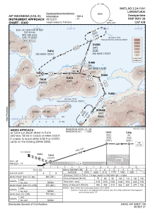
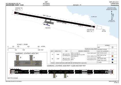
Runways:
| RWY identifier | QFU | Length (ft) | Width (ft) | Surface | LDA (ft) |
| 10 | 99° | 5249 | 98 | UNK | |
| 28 | 279° | 5249 | 98 | UNK |
Airport contact information
Address: Larantuka Indonesia