


WATG - Ruteng/Frans Sales Lega
Located in Ruteng, Indonesia
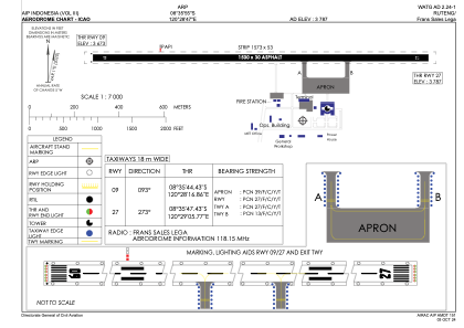
ICAO - WATG, IATA - RTG
Data provided by AirmateGeneral information
Coordinates: S8°35'55" E120°28'47"
Elevation is 3777 feet MSL.
View others Airports in Nusa Tenggara Timur
Operational data
Special qualification required
Current time UTC:
Current local time:
Weather at : - ( 0 km )
METAR: KQFX 191810Z AUTO 13001KT 6000 HZ BKN180 13/10 A2987 RMK A02 TSNO
Communications frequencies: [VIEW]
Runways:
| RWY identifier | QFU | Length (ft) | Width (ft) | Surface | LDA (ft) |
| 09 | 93° | 4921 | 98 | ASP | |
| 27 | 273° | 4921 | 98 | ASP |
Airport contact information
Address: Ruteng Indonesia