


WASI - Inanwatan / Inanwatan
Located in Inanwatan, Indonesia
ICAO - WASI, IATA - INX
Data provided by AirmateGeneral information
Coordinates: S2°7'36" E132°9'47"
Elevation is 36 feet MSL.
Magnetic variation is 1° East View others Airports in Irian Jaya
Operational data
Special qualification required
Current time UTC:
Current local time:
Weather at : - ( 0 km )
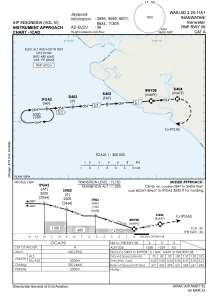
METAR: SARI 231851Z 09009KT 9999 FEW004 OVC050 21/21 Q1013
Communications frequencies: [VIEW]
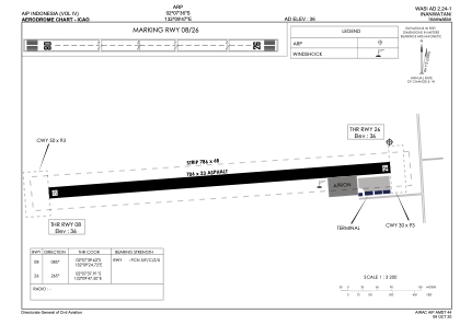
Runways:
| RWY identifier | QFU | Length (ft) | Width (ft) | Surface | LDA (ft) |
| 08 | 86° | 2316 | 75 | ASP | |
| 26 | 266° | 2316 | 75 | ASP |
Airport contact information
Address: Inanwatan Indonesia