


WASA - Maybrat / Ayawasi
Located in Wasa, Indonesia
ICAO - , IATA - AYW
Data provided by AirmateGeneral information
Coordinates: S1°9'35" E132°27'55"
Elevation is 1525 feet MSL.
Magnetic variation is 1° East View others Airports in Irian Jaya
Operational data
Special qualification required
Current time UTC:
Current local time:
Weather at : - ( 0 km )
METAR: CYNM 200037Z AUTO 25010G17KT 9SM -RA BKN011 OVC016 03/02 A2955 RMK PCPN 0.5MM PAST HR SLP020
Communications frequencies: [VIEW]
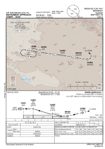
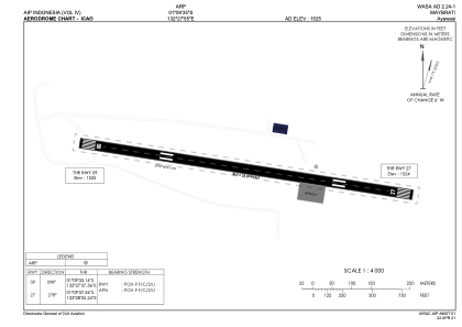
Runways:
| RWY identifier | QFU | Length (ft) | Width (ft) | Surface | LDA (ft) |
| 09 | 99° | 2838 | 75 | UNK | |
| 27 | 279° | 2838 | 75 | UNK |
Airport contact information
Address: Wasa Indonesia