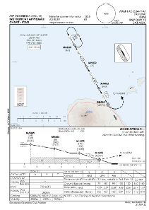
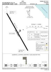


WAMH - Tahuna / Naha
Located in Tahuna, Indonesia
ICAO - WAMH, IATA - NAH
Data provided by AirmateGeneral information
Coordinates: N3°41'8" E125°31'45"
Elevation is 63 feet MSL.
Magnetic variation is 0° East View others Airports in Sulawesi Utara
Operational data
Special qualification required
Current time UTC:
Current local time:
Communications frequencies: [VIEW]
Runways:
| RWY identifier | QFU | Length (ft) | Width (ft) | Surface | LDA (ft) |
| 15 | 150° | 4921 | 98 | ASP | |
| 33 | 330° | 4921 | 98 | ASP |
Airport contact information
Address: Tahuna Indonesia