


WAKM - Kamur / Asmat
Located in Kamur, Indonesia
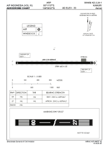
ICAO - , IATA - KCD
Data provided by AirmateGeneral information
Coordinates: S6°11'7" E138°38'27"
Elevation is 33 feet MSL.
View others Airports in Papua
Operational data
Special qualification required
Current time UTC:
Current local time:
Weather at : - ( 0 km )
METAR: MMMX 040140Z 07014KT 7SM BKN020 BKN080 OVC220 21/10 A3017 NOSIG RMK 8/463 HZY PCPN 1ST 2ND QUAD TSE25
Communications frequencies: [VIEW]
Runways:
| RWY identifier | QFU | Length (ft) | Width (ft) | Surface | LDA (ft) |
| 09 | 0° | 1969 | 59 | UNK | |
| 27 | 0° | 1969 | 59 | UNK |
Airport contact information
Address: Kamur Indonesia