


WAFF - Palu / Mutiara Sis Al-Jufri
Located in Palu, Indonesia
ICAO - , IATA - PLW
Data provided by AirmateGeneral information
Coordinates: S0°55'50" E119°54'37"
Elevation is 288 feet MSL.
View others Airports in Sulawesi Tengah
Operational data
Special qualification required
Current time UTC:
Current local time:
Weather at : - ( 0 km )
METAR: OPLA 260425Z 09003KT 5000 HZ FEW040 SCT100 30/16 Q1007 NOSIG RMK QFE981 A29.74
Communications frequencies: [VIEW]
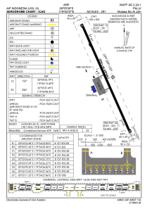
Runways:
| RWY identifier | QFU | Length (ft) | Width (ft) | Surface | LDA (ft) |
| 15 | 156° | 6890 | 148 | UNK | |
| 33 | 336° | 6890 | 148 | UNK |
Airport contact information
Address: Palu Indonesia