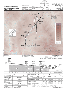


WAFB - Tana Toraja / Toraja
Located in Makale, Indonesia
ICAO - , IATA -
Data provided by AirmateGeneral information
Coordinates: S3°11'8" E119°55'2"
Elevation is 3026 feet MSL.
View others Airports in Sulawesi Selatan
Operational data
Special qualification required
Current time UTC:
Current local time:
Weather at : - ( 0 km )
METAR: KXSA 280535Z AUTO 00000KT 10SM CLR 15/13 A3028 RMK AO2 T01450127
Communications frequencies: [VIEW]
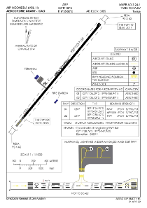
Runways:
| RWY identifier | QFU | Length (ft) | Width (ft) | Surface | LDA (ft) |
| 04 | 39° | 6562 | 98 | UNK | |
| 22 | 219° | 6562 | 98 | UNK |
Airport contact information
Address: Makale Indonesia