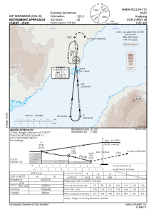
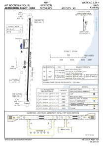


WAEK - Kao / Kuabang
Located in , Indonesia
ICAO - , IATA - KAZ
Data provided by AirmateGeneral information
Coordinates: N1°11'13" E127°53'42"
Elevation is 40 feet MSL.
View others Airports in Maluku Utara
Operational data
Special qualification required
Current time UTC:
Current local time:
Weather at : - ( 0 km )
METAR: KBCT 231153Z 06015KT 10SM FEW030 22/14 A3009
Communications frequencies: [VIEW]
Runways:
| RWY identifier | QFU | Length (ft) | Width (ft) | Surface | LDA (ft) |
| 18 | 182° | 7874 | 98 | UNK | |
| 36 | 2° | 7874 | 98 | UNK |
Airport contact information
Address: Indonesia