


WADB - Bima / Sultan Muhammad Salahuddin
Located in Bima Nusa Tenggara Barat, Indonesia
ICAO - WADB, IATA - BMU
Data provided by AirmateGeneral information
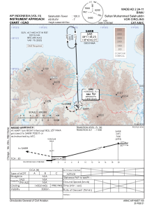
Coordinates: S8°32'26" E118°41'25"
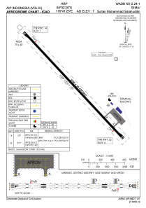
Elevation is 9 feet MSL.
View others Airports in Nusa Tenggara Barat
Operational data
Special qualification required
Current time UTC:
Current local time:
Weather at : - ( 0 km )
METAR: PAJC 240106Z AUTO 11009G17KT 10SM -RA BKN013 OVC019 04/02 A2973 RMK AO2 P0000 $
Communications frequencies: [VIEW]
Runways:
| RWY identifier | QFU | Length (ft) | Width (ft) | Surface | LDA (ft) |
| 14 | 138° | 7218 | 98 | UNK | |
| 32 | 318° | 7218 | 98 | UNK |
Airport contact information
Address: Bima Nusa Tenggara Barat Indonesia