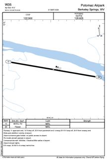


W35 - Potomac Airpark
Located in Berkeley Springs, United States
ICAO - W35, IATA -
Data provided by AirmateGeneral information
Coordinates: N39°41'33" W78°9'58"
Elevation is 413 feet MSL.
Magnetic variation is -10° East View others Airports in West Virginia
Operational data
Special qualification required
Current time UTC:
Current local time:
Weather at : KMRB - Eastern Wv Rgnl/Shepherd Fld ( 36 km )
METAR: KMRB 281853Z 19008KT 160V230 10SM CLR 27/16 A3009 RMK AO2 SLP188 T02670156
TAF: KMRB 281732Z 2818/2918 00000KT P6SM SKC FM282200 22007KT P6SM SCT050 SCT250 FM290400 23002KT P6SM FEW250 FM291000 00000KT 4SM BR SCT250 FM291700 20004KT P6SM SCT050 BKN250
Communications frequencies: [VIEW]
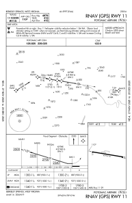
Runways:
| RWY identifier | QFU | Length (ft) | Width (ft) | Surface | LDA (ft) |
| 11 | 100° | 4979 | 70 | ASPH | |
| 29 | 280° | 4979 | 70 | ASPH |
Airport contact information
Address: Berkeley Springs United States