


W09 - Lower Monumental State
Located in Kahlotus, United States
ICAO - W09, IATA -
Data provided by AirmateGeneral information
Coordinates: N46°32'59" W118°32'12"
Elevation is 813 feet MSL.
Magnetic variation is 19° East View others Airports in Washington
Operational data
Special qualification required
Current time UTC:
Current local time:
Weather at : KALW - Walla Walla Rgnl ( 54 km )
METAR: KALW 041353Z 08013G19KT 10SM -RA FEW055 SCT075 OVC090 17/02 A2956 RMK AO2 RAB01 SLP005 P0000 T01670022
TAF: KALW 041400Z 0414/0512 15016G28KT P6SM VCSH SCT050 OVC100 FM041700 12009KT P6SM OVC100 FM050200 17011KT 6SM -SHRA BR OVC050 FM050600 19013G23KT 6SM -RA BR OVC020
Communications frequencies: [VIEW]
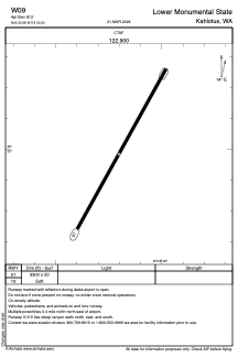
Runways:
| RWY identifier | QFU | Length (ft) | Width (ft) | Surface | LDA (ft) |
| 01 | 29° | 3300 | 50 | GRAVEL | |
| 19 | 209° | 3300 | 50 | GRAVEL |
Airport contact information
Address: Kahlotus United States