


VYYY - Yangon / Yangon International
Located in Yangon, Myanmar
ICAO - VYYY, IATA - RGN
Data provided by AirmateGeneral information
Coordinates: N16°54'26" E96°7'60"
Elevation is 110 feet MSL.
View others Airports in Yangon Division
Operational data
Special qualification required
Current time UTC:
Current local time:
Weather
METAR: VYYY 291230Z 25003KT 7000 FEW025 34/29 Q1005 NOSIG
TAF: TAF VYYY 291100Z 2912/3012 26006KT 8000 FEW025 SCT110 TEMPO 2912/2918 25010KT 7000 FEW020
Communications frequencies: [VIEW]
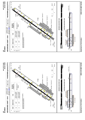
Runways:
| RWY identifier | QFU | Length (ft) | Width (ft) | Surface | LDA (ft) |
| 03 | 34° | 11201 | 197 | ASP | |
| 21 | 214° | 11201 | 197 | ASP |
Airport contact information
Address: Yangon Myanmar