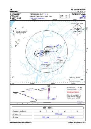


VYPN - Pathein
Located in Pathein, Myanmar
ICAO - VYPN, IATA - BSX
Data provided by AirmateGeneral information
Coordinates: N16°48'44" E94°46'26"
Elevation is 13 feet MSL.
View others Airports in Ayeyarwady Division
Operational data
Special qualification required
Current time UTC:
Current local time:
Weather at : - ( 0 km )
METAR: KMYP 042123Z AUTO 21016G21KT 10SM BKN050 OVC065 04/M07 A3032 RMK AO2
Communications frequencies: [VIEW]
Runways:
| RWY identifier | QFU | Length (ft) | Width (ft) | Surface | LDA (ft) |
| 06 | 64° | 9301 | 200 | CON | |
| 24 | 244° | 9301 | 200 | CON |
Airport contact information
Address: Pathein Myanmar