


VYAN - Ann
Located in , Myanmar
ICAO - VYAN, IATA - VBA
Data provided by AirmateGeneral information
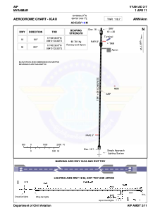
Coordinates: N19°46'9" E94°1'34"
Elevation is 53 feet MSL.
View others Airports in Rakhine State
Operational data
Special qualification required
Current time UTC:
Current local time:
Weather at : - ( 0 km )
METAR: PAGH 291126Z AUTO 30005KT 3SM BR OVC003 M03/M04 A3005 RMK AO2 FZRANO
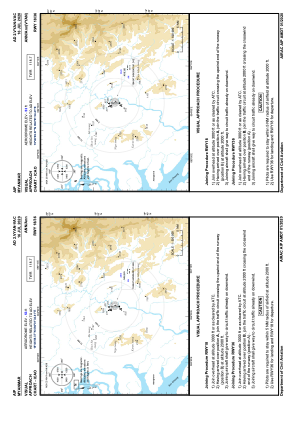
Communications frequencies: [VIEW]
Runways:
| RWY identifier | QFU | Length (ft) | Width (ft) | Surface | LDA (ft) |
| 18 | 181° | 8501 | 98 | CON | |
| 36 | 1° | 8501 | 98 | CON |
Airport contact information
Address: Myanmar