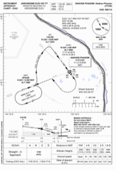
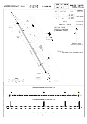


VTUW - Nakhon Phanom / Nakhon Phanom Airport
Located in Nakhon Phanom, Thailand
ICAO - VTUW, IATA - KOP
Data provided by AirmateGeneral information
Coordinates: N17°23'7" E104°38'31"
Elevation is 587 feet MSL.
View others Airports in Nakhon Phanom Province
Operational data
Special qualification required
Current time UTC:
Current local time:
Weather
METAR: VTUW 022300Z 34002KT 8000 FEW035 27/24 Q1008 NOSIG
TAF: TAF VTUW 021700Z 0218/0318 19005KT 8000 FEW030
Communications frequencies: [VIEW]
Runways:
| RWY identifier | QFU | Length (ft) | Width (ft) | Surface | LDA (ft) |
| 15 | 145° | 8202 | 148 | ASP | |
| 33 | 325° | 8202 | 148 | ASP |
Airport contact information
Address: Nakhon Phanom Thailand
Other aviation service providers
Aviation club (not for profit)

International Aviation College - Nakhon Phanom University
International Aviation College - Nakhon Phanom University
iac@npu.ac.th6642531575