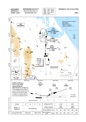
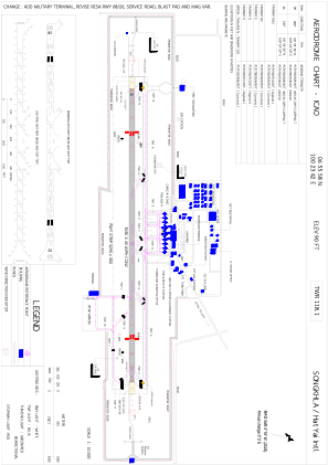


VTSS - Songkhla / Hat Yai International Airport
Located in Songkhla, Thailand
ICAO - VTSS, IATA - HDY
Data provided by AirmateGeneral information
Coordinates: N6°55'58" E100°23'42"
Elevation is 90 feet MSL.
View others Airports in Songkhla Province
Operational data
Special qualification required
Current time UTC:
Current local time:
Weather
METAR: VTSS 271730Z 00000KT 9999 FEW020 28/25 Q1007 NOSIG
TAF: TAF VTSS 271700Z 2718/2818 00000KT 9999 FEW020 BECMG 2804/2806 06010KT PROB40 TEMPO 2806/2812 VRB15G25KT -TSRA FEW016CB SCT018 BKN100 BECMG 2815/2817 12003KT
Communications frequencies: [VIEW]
Runways:
| RWY identifier | QFU | Length (ft) | Width (ft) | Surface | LDA (ft) |
| 08 | 82° | 10007 | 148 | ASP | |
| 26 | 262° | 10007 | 148 | ASP |
Airport contact information
Address: Songkhla Thailand