


VTPT - Tak / Tak Airport
Located in Tak, Thailand
ICAO - VTPT, IATA - TKT
Data provided by AirmateGeneral information
Coordinates: N16°53'46" E99°15'13"
Elevation is 478 feet MSL.
View others Airports in Tak Province
Operational data
Special qualification required
Current time UTC:
Current local time:
Weather
METAR: VTPT 290100Z /////KT 7000 NSC 32/22 Q1009 NOSIG
TAF: TAF VTPT 282300Z 2900/2924 24005KT 8000 FEW026
Communications frequencies: [VIEW]
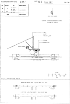
Runways:
| RWY identifier | QFU | Length (ft) | Width (ft) | Surface | LDA (ft) |
| 09 | 91° | 4921 | 98 | ASP | |
| 27 | 271° | 4921 | 98 | ASP |
Airport contact information
Address: Tak Thailand