


VRMR - Fuvahmulah Island/Airport
Located in Fuvahmulah, Maldives
ICAO - , IATA - FVM
Data provided by AirmateGeneral information
Coordinates: S0°18'34" E73°25'58"
Elevation is 6 feet MSL.
View others Airports in Gnaviyani
Operational data
Special qualification required
Current time UTC:
Current local time:
Weather at : VRMG - Gan Island/International ( 53 km )
METAR: VRMG 020000Z 26007KT 9999 FEW018TCU BKN260 28/26 Q1007 TEMPO 5000 TSRA
TAF: TAF VRMG 012300Z 0200/0306 26009KT 9999 SCT017TCU SCT100 TEMPO 0200/0206 5000 TSRA FEW016CB
Communications frequencies: [VIEW]
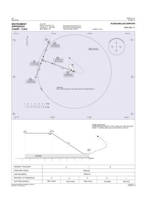
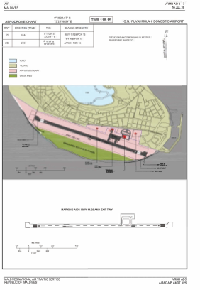
Runways:
| RWY identifier | QFU | Length (ft) | Width (ft) | Surface | LDA (ft) |
| 11 | 106° | 3609 | 98 | UNK | |
| 29 | 286° | 3609 | 98 | UNK |
Airport contact information
Address: Fuvahmulah Maldives