


VRGD - Madivaru Island
Located in Naifaru, Maldives
ICAO - , IATA -
Data provided by AirmateGeneral information
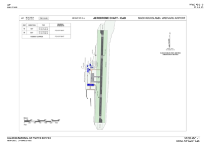
Coordinates: N5°27'28" E73°22'13"
Elevation is 6 feet MSL.
Magnetic variation is -3° East View others Airports in Haa Dhaalu Atoll
Operational data
Special qualification required
Current time UTC:
Current local time:
Communications frequencies: [VIEW]
Runways:
| RWY identifier | QFU | Length (ft) | Width (ft) | Surface | LDA (ft) |
| 18 | 181° | 4347 | 94 | ASPH | 3937 |
| 36 | 1° | 4347 | 94 | ASPH | 3937 |
Airport contact information
Address: Naifaru Maldives