


VQGP - Sarpang, Gelephu
Located in Gelephu, Bhutan
ICAO - VQGP, IATA - GLU
Data provided by AirmateGeneral information
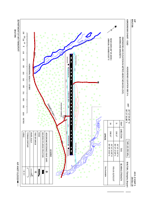
Coordinates: N26°53'4" E90°27'51"
Elevation is 987 feet MSL.
View others Airports in Sarpang
Operational data
Special qualification required
Current time UTC:
Current local time:
Weather at : - ( 0 km )
METAR: YBHM 041706Z AUTO 16017KT 9999 // SCT009 BKN015 BKN021 22/21 Q1013
Communications frequencies: [VIEW]
Runways:
| RWY identifier | QFU | Length (ft) | Width (ft) | Surface | LDA (ft) |
| 11 | 118° | 4941 | 98 | Asphalt | |
| 29 | 297° | 4941 | 98 | Asphalt |
Airport contact information
Address: Gelephu Bhutan