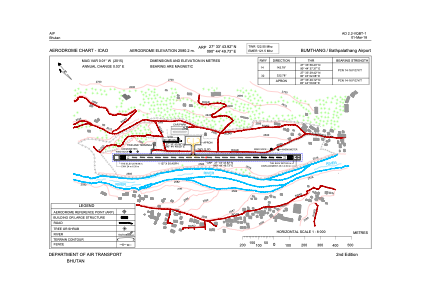


VQBT - Bumthang, Bathbalathang
Located in Chamkhar, Bhutan
ICAO - , IATA - BUT
Data provided by AirmateGeneral information
Coordinates: N27°33'44" E90°44'50"
Elevation is 8465 feet MSL.
View others Airports in Sarpang
Operational data
Special qualification required
Current time UTC:
Current local time:
Weather at : - ( 0 km )
METAR: KBKF 040558Z 07006KT 10SM FEW060 SCT140 01/M02 A3015 RMK AO2A SLP172 T00131016 10123 20013 52029
Communications frequencies: [VIEW]
Runways:
| RWY identifier | QFU | Length (ft) | Width (ft) | Surface | LDA (ft) |
| 14 | 143° | 3937 | 98 | UNK | |
| 32 | 323° | 3937 | 98 | UNK |
Airport contact information
Address: Chamkhar Bhutan