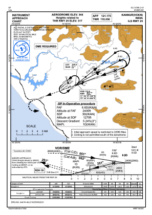
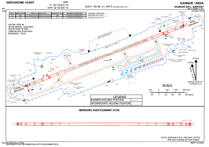


VOKN - Kannur International Airport, Mattannur, Kannur
Situé à Mattannur, India
ICAO - , IATA - CNN
Données fournies par AirmateInformation générale
Coordonnées: N11°54'57" E75°32'45"
Élévation : 344 feet MSL.
Voir autres Aéroports à Kerala
Données opérationnelles
Special qualification required
Heure actuelle UTC:
Heure actuelle locale:
Météo
METAR: VOKN 141130Z 23010KT 6000 FEW015 FEW025CB SCT080 32/23 Q1006 NOSIG
TAF: TAF VOKN 141100Z 1412/1518 28010KT 6000 BR FEW015 SCT080 BECMG 1415/1417 12005KT 5000 BR SCT012 BKN080 TEMPO 1422/1502 VRB02KT 3000 BR FEW012 SCT080 BECMG 1503/1505 20005KT 5000 HZ FEW015 SCT080 TEMPO 1510/1512 29010KT 4000 -TSRA RA SCT012 FEW025CB BKN080 BECMG 1514/1516 10005KT 3000 -RA BR
Fréquences de communication: [VIEW]
Pistes:
| Identifiant RWY | QFU | Longueur (ft) | Largeur (ft) | Surface | LDA (ft) |
| 07 | 69° | 10007 | 148 | UNK | |
| 25 | 249° | 10007 | 148 | UNK |
Coordonnées de l'aéroport
Adresse: Mattannur India