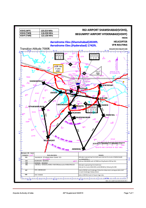
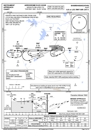


VOHS - Rajiv Gandhi International Airport, Shamshabad
Located in Husain Sagar, India
ICAO - VOHS, IATA - HYD
Data provided by AirmateGeneral information
Coordinates: N17°14'26" E78°25'44"
Elevation is 2028 feet MSL.
View others Airports in Andhra Pradesh
Operational data
Special qualification required
Current time UTC:
Current local time:
Weather
METAR: VOHS 032330Z 10006KT 6000 NSC 27/23 Q1010 NOSIG
TAF: TAF VOHS 032300Z 0400/0409 30006KT 6000 SCT015 TEMPO 0400/0404 VRB04KT 5000 HZ FEW020 BECMG 0404/0406 23010KT 6000 FEW015 SCT025
Communications frequencies: [VIEW]
Runways:
| RWY identifier | QFU | Length (ft) | Width (ft) | Surface | LDA (ft) |
| 09R | 89° | 13976 | 197 | UNK | |
| 27L | 269° | 13976 | 197 | UNK | |
| 09L | 89° | 12162 | 148 | UNK | |
| 27R | 269° | 12162 | 148 | UNK |
Airport contact information
Address: Husain Sagar India