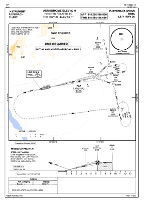
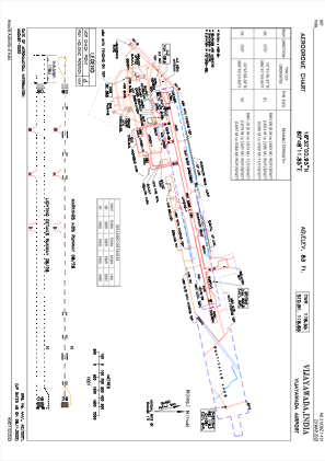


VOBZ - Vijayawada Airport, Vijayawada
Located in Vijayawada, India
ICAO - VOBZ, IATA - VGA
Data provided by AirmateGeneral information
Coordinates: N16°32'1" E80°48'12"
Elevation is 83 feet MSL.
View others Airports in Andhra Pradesh
Operational data
Special qualification required
Current time UTC:
Current local time:
Weather
TAF: TAF VOBZ 032000Z 0321/0406 16006KT 5000 HZ FEW020 TEMPO 0400/0403 VRB03KT 3000 HZ BR SCT015 BECMG 0404/0406 19010KT 6000 SCT015 SCT025
Communications frequencies: [VIEW]
Runways:
| RWY identifier | QFU | Length (ft) | Width (ft) | Surface | LDA (ft) |
| 08 | 78° | 11024 | 148 | ASP | |
| 26 | 258° | 11024 | 148 | ASP |
Airport contact information
Address: Vijayawada India