


VOAT - Agatti Airport
Located in Agatti, India
ICAO - VOAT, IATA - AGX
Data provided by AirmateGeneral information
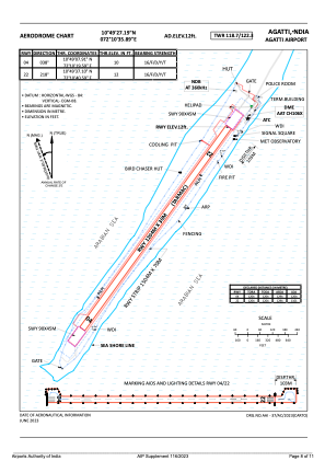
Coordinates: N10°49'27" E72°10'36"
Elevation is 14 feet MSL.
View others Airports in Lakshadweep
Operational data
Special qualification required
Current time UTC:
Current local time:
Weather
TAF: TAF VOAT 272300Z 2800/2809 32005KT 3000 HZ SCT015 BECMG 2803/2805 32005KT 5000 HZ SCT015
Communications frequencies: [VIEW]
Runways:
| RWY identifier | QFU | Length (ft) | Width (ft) | Surface | LDA (ft) |
| 04 | 35° | 3950 | 98 | ASP | |
| 22 | 215° | 3950 | 98 | ASP |
Airport contact information
Address: Agatti India