


VIDP - Indira Gandhi International Airport, Delhi
Located in Delhi, India
ICAO - VIDP, IATA - DEL
Data provided by AirmateGeneral information
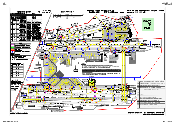
Coordinates: N28°34'7" E77°6'44"
Elevation is 778 feet MSL.
View others Airports in Delhi
Operational data
Special qualification required
Current time UTC:
Current local time:
Weather
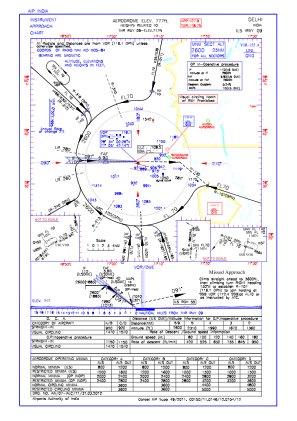
METAR: VIDP 020230Z 27005KT 1300 R28/2000 R27/1800 R29R/2000 R29L/2000 HZ NSC 24/06 Q1006 BECMG 1500 HZ
TAF: TAF VIDP 020200Z 0203/0212 27006KT 2000 HZ NSC BECMG 0204/0206 3000 HZ BECMG 0208/0210 31010G20KT 5000 HZ
Communications frequencies: [VIEW]
Runways:
| RWY identifier | QFU | Length (ft) | Width (ft) | Surface | LDA (ft) |
| 09 | 91° | 9239 | 148 | ASP | |
| 27 | 271° | 9239 | 148 | ASP | |
| 10 | 104° | 12510 | 148 | ASP | |
| 28 | 284° | 12510 | 148 | ASP | |
| 11R | 103° | 14534 | 197 | UNK | |
| 29L | 283° | 14534 | 197 | UNK | |
| 11L | 104° | 14436 | 148 | UNK | |
| 29R | 284° | 14436 | 148 | UNK |
Airport contact information
Address: Delhi India