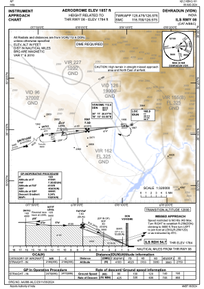
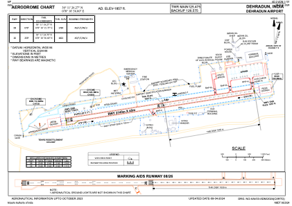


VIDN - Dehradun Airport
Located in Dehradun, India
ICAO - VIDN, IATA - DED
Data provided by AirmateGeneral information
Coordinates: N30°11'26" E78°10'56"
Elevation is 1856 feet MSL.
View others Airports in Uttar Pradesh
Operational data
Special qualification required
Current time UTC:
Current local time:
Weather
METAR: VIDN 271630Z 33003G27KT 3000 HZ SCT025 BKN060 24/08 Q1011 NOSIG
TAF: TAF VIDN 271100Z 2712/2721 04015G25KT 5000 HZ SCT025 SCT040 TEMPO 2714/2717 05010G20KT 2000 TSRA SCT030 FEW035CB SCT100 BECMG 2718/2720 07005KT 4000 HZ SCT090
Communications frequencies: [VIEW]
Runways:
| RWY identifier | QFU | Length (ft) | Width (ft) | Surface | LDA (ft) |
| 08 | 80° | 7021 | 148 | ASP | |
| 26 | 260° | 7021 | 148 | ASP |
Airport contact information
Address: Dehradun India