


VIBR - Kullu Manali Airport, Bhuntar
Located in Kullu, India
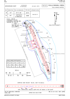
ICAO - VIBR, IATA - KUU
Data provided by AirmateGeneral information
Coordinates: N31°52'37" E77°9'19"
Elevation is 3573 feet MSL.
View others Airports in Himachal Pradesh
Operational data
Special qualification required
Current time UTC:
Current local time:
Weather
TAF: VIBR 070500Z 0706/0715 00000KT 6000 NSC TEMPO 0709/0712 2500 TSRA FEW030CB BKN060
Communications frequencies: [VIEW]
Runways:
| RWY identifier | QFU | Length (ft) | Width (ft) | Surface | LDA (ft) |
| 16 | 159° | 3442 | 98 | ASP | |
| 34 | 339° | 3442 | 98 | ASP |
Airport contact information
Address: Kullu India