


VEKO - Khajuraho Airport, Khajuraho
Located in Khajuraho, India
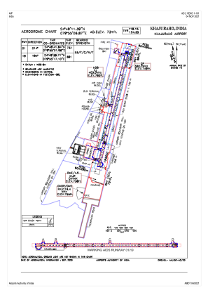
ICAO - , IATA - HJR
Data provided by AirmateGeneral information
Coordinates: N24°49'11" E79°55'7"
Elevation is 728 feet MSL.
View others Airports in Madhya Pradesh
Operational data
Special qualification required
Current time UTC:
Current local time:
Weather
METAR: VEKO 020600Z 20005KT 6000 NSC 34/01 Q1006
TAF: TAF VEKO 020200Z 0203/0212 02010KT 5000 HZ NSC BECMG 0207/0209 32010KT
Communications frequencies: [VIEW]
Runways:
| RWY identifier | QFU | Length (ft) | Width (ft) | Surface | LDA (ft) |
| 01 | 13° | 7500 | 148 | UNK | |
| 19 | 193° | 7500 | 148 | UNK |
Airport contact information
Address: Khajuraho India