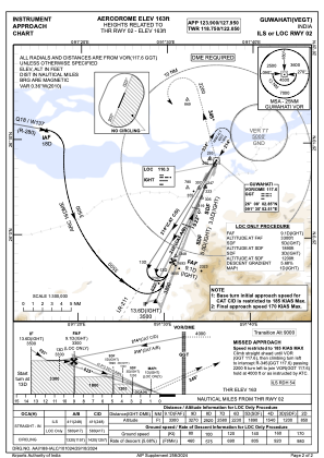
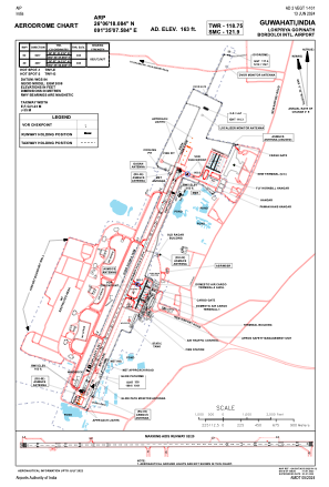


VEGT - Lokpriya Gopinath Bordoloi International Airport, Guwahati
Located in Guwahati, India
ICAO - VEGT, IATA - GAU
Data provided by AirmateGeneral information
Coordinates: N26°6'18" E91°35'8"
Elevation is 162 feet MSL.
View others Airports in Assam
Operational data
Special qualification required
Current time UTC:
Current local time:
Weather
METAR: VEGT 290400Z 36006KT 3500 BR FEW020 28/23 Q1007 NOSIG
TAF: TAF VEGT 290200Z 2903/2912 05007KT 3000 HZ SCT018 BKN100 BECMG 2905/2907 29008KT 3000 HZ FEW020 SCT100
Communications frequencies: [VIEW]
Runways:
| RWY identifier | QFU | Length (ft) | Width (ft) | Surface | LDA (ft) |
| 02 | 23° | 10187 | 148 | ASP | |
| 20 | 203° | 10187 | 148 | ASP |
Airport contact information
Address: Guwahati India