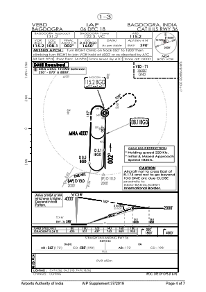


VEBD - Bagdogra
Located in Siliguri, India
ICAO - VEBD, IATA - IXB
Data provided by AirmateGeneral information
Coordinates: N26°41'7" E88°19'38"
Elevation is 414 feet MSL.
View others Airports in West Bengal
Operational data
Special qualification required
Current time UTC:
Current local time:
Weather
TAF: TAF VEBD 291100Z 2912/3018 27005KT 5000 HZ FEW030 SCT100 TEMPO 3008/3012 FEW025 FEW030CB SCT100
Communications frequencies: [VIEW]
Runways:
| RWY identifier | QFU | Length (ft) | Width (ft) | Surface | LDA (ft) |
| 18 | 182° | 8999 | 148 | PEM | |
| 36 | 2° | 8999 | 148 | PEM |
Airport contact information
Address: Siliguri India