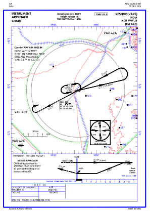
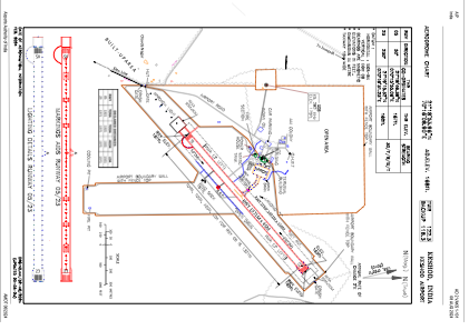


VAKS - Keshod Airport
Located in Keshod, India
ICAO - VAKS, IATA - IXK
Data provided by AirmateGeneral information
Coordinates: N21°18'54" E70°16'9"
Elevation is 167 feet MSL.
View others Airports in Gujarat
Operational data
Special qualification required
Current time UTC:
Current local time:
Weather at : VAPR - Porbandar Airport ( 73 km )
METAR: VAPR 290900Z 27016KT 6000 NSC 36/23 Q1009 NOSIG
TAF: TAF VAPR 290800Z 2909/2918 28015KT 6000 NSC TEMPO 2909/2913 29015G25KT BECMG 2913/2915 28012KT 5000 FU BECMG 2916/2918 33009KT
Communications frequencies: [VIEW]
Runways:
| RWY identifier | QFU | Length (ft) | Width (ft) | Surface | LDA (ft) |
| 05 | 50° | 4498 | 148 | ASP | |
| 23 | 230° | 4498 | 148 | ASP |
Airport contact information
Address: Keshod India